On Easter Sunday I received a call from the Nantahala Outdoor Center. They had accepted my application and wanted me to come and work as a river guide on the Ocoee River. I was asked to start training for May 1st. Of course, I graciously said yes. Now I have been here for a week and my river education is flowing. This post though, is not about life here on the river, the famous Whitewater Center that hosted the 1996 Olympic events or even the power of the class IV rapids that are kicking my butt. The historian in me needed to be satiated on the story of this small part of the country's past, and that is our topic of interest today. After all I did get my degree in History.
In the great story of the development of our nation one of the major overreaching themes that can be interjected in countless places is the tale of Industrialization. Communities across this country were built, advanced and doomed by the process. The area around the Ocoee River in the South East portion of Tennessee was no exception. Her industry: Copper.

Polk County, in this section of Tennessee, has been dubbed by history the "Copper Basin". The knowledge of copper, in the hills of this quite section of the Southern Appalachians, predates settlement by white westerners. The Native Americans who took these lands as their ancestral home were aware of the mineral deposits but could not fathom how rich they truly were. That wealth would only become known and exploited by American and European prospectors in the following decades. They built an industry that would effect the area for over 150 years. A period spanning the growth of American Industrialization, the Civil War, the Second World War and even into modern times.
The ability for the native Cherokee Indians to utilize the valuable resource was minor and artifacts are rare. Their use of the bits of copper was limited to that which was on the surface of the hills and washed out into the creeks and rivers in the area. It was, however, still a valuable commodity for the native peoples.

It had been falsely reported early on that gold was in the hills. The Treaty of New Echota in 1835, which ceded Cherokee lands in the southeast to the United States and their subsequent removal by means of the infamous Trail of Tears, opened the area to prospecting for westerners. As early as 1831 the first geologist of the state of Tennessee had noted the presence of "hydroxide of iron" or "gossan" near the area of modern Ducktown around Coker Creek. It was not until 1843 that the deposits containing copper and iron were fully confirmed with the discovery of the ore by a gold prospector near Potato Creek. Originally the prospector believed his find to be gold but a through examination revealed reddish crystals indicating copper. Shortly after the discovery it was believed that the area contained one of the largest deposits of copper ever found.
By 1847 a small foundry was built on Potato Creek by B.C. Duggar to extract iron. The foundry exploited only the surface ore that was of poor quality and eventually the venture failed due to high copper content. In that same year A.J. Weaver successfully produced the first shipment of copper ore from the basin. That first shipment was 31,000lbs of ore and yielded only about 25% pure copper. The ore was transported by mule carts over the mountains to Dalton GA where the nearest railroad was. The lack of a transportation network severely hurt the ability to take advantage of the resource. It was not until the 1850's that the area would truly develop a semblance of infrastructure capable of utilizing the richness of the deposit.

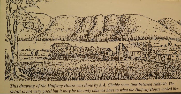
The 1850's saw a boom in the industry and the creation of the town of Hiwassee (modern Ducktown) along with the construction of the Copper Road connecting Cleveland TN to Hiwassee via the Ocoee River Gorge. The road was completed in 1851 and opened up new economic opportunity for the growing community. The ore was transported via mule carts along this 40 mile route. The trip took haulers two days each way and they overnighted each way at a "Halfway House". Today, along U.S. Hwy 64 there is a state historical marker commemorating the spot. The forest service still maintains part of the road as a public hiking trail for historical and recreational purposes. The wagoneers would transport goods and supplies back to the developing mining operation and towns in the area from Cleveland. At the middle of the decade over 14 companies were mining and using the road that is now Hwy 64. Around the end of the decade the companies had consolidated into three: Union Consolidated, Burra Burra, and Ducktown Copper. (Burra Burra was headquartered in good ole' New Orleans as it happens) Eventually most mining operations would merge near the end of the century to create the Tennessee Copper Company that would remain active through the 1950's.
 |
| Copper Road through Ocoee Gorge. |
Of the "Copper Haulers" a man by the name of G.B. Barnes has made his mark on history. Reportedly he was the last man to use the road for transportation of copper before other means of transportation supplanted the traditional route. His claim to fame, however, was his ability to play the fiddle and give some degree of entertainment to his fellow wagoneers. In a clearly fictional story about Barnes it is reported that his mules became so familiar with is repertoire that on one occasion while bogged down in mud they noticed him removing his fiddle to pass the time. Upon noticing this the mules quickly stepped up to the challenge and promptly drew the wagon out of the muck and pushed onto Cleveland.
Like so many other places in the south the Civil War in 1861 saw drastic change for the Copper Basin. There was a halt in mining operations, which, oddly enough, were mostly owned by wealthy northern industrialists. The Confederacy regained control of the mines in 1863 and then promptly sold them off to southerners. Eventually the mines were retaken by Union forces who in turn devastated the area by destroying facilities and equipment.
Following the war production in the mines slowly resumed as the infrastructure was rebuilt, however most of the ore on the surface had been depleted. The solution was deep shaft mining. By 1877 the area was operating the only deep shaft mines east of the Mississippi. Some of these mines would reach depths of over 3,000 feet in their years of operation. Highly dangerous, deep shaft mining required drilling and explosives that exposed miners to risks much greater than surface production.
Towards the turn of the century production became limited due to lack of a rail network. It was this need that prompted the development of the famous Bald Mountain rail line (still operational to this day and open for tourism) by architect T.A. Aber. The rail line circled around the peak 1 1/2 times to overcome the 426 foot elevation difference from one rim to the other in the Hiwassee Gorge.
The later parts of the 19th century saw a major change in the industry via the production of Sulfuric Acid. As the ore was smelt it released sulfuric acid into the atmosphere and consequently created acid rain. From the 1890's and into the 1900's a number of major injunctions were filed against the mining companies by local land owners for the devastation. Eventually a solution was devised to collect the sulfuric acid to make fertilizer and products for sale that furthered new industry. By the 1920's methods of extraction via "flotation plants" had devised means to facilitate other products such as zinc, sulfur dioxide, and iron sulfate creating even greater markets.


The story of the Copper Basin the middle to late 20th century saw a change in concern for the environment. In terms of ecological impact, the smelting of the ore required huge quantities of wood to fuel the furnaces. The wood came from the forests in the neighboring hills. The closer to the mines the better. In time the areas surrounding the mines were denuded and removed of their vegetation creating a "moonscape" appearance The area had been devastated by the removal of local flora and the chemicals that had run off into the local waterways began to prove toxic. In the new deal era the C.C.C planted trees in the area in an attempt to reforest the landscape and a clean up of water sources. The years between 1920 and 1950 thousands of acres of land were revitalized with pine and local species of trees.
 |
| Deforested area around the mines. HWY64 runs the right side of the photo. |
 |
| Area reforested today. You can see the pit mine and Gossan ruts still visible. |
The area saw a complete cease in iron production in the 1980's but the industry of the area was still very active. The chemical plants that had once harvested the byproducts of the smelting process began to import raw materials from other parts of the country and continued to produce numerous chemical compounds for national and international markets.
Today chemical production continues in the area but a major part of the economy has been replaced by tourism through the numerous companies operating outdoor adventure activities around the Ocoee River. With the creation of the Ocoee dam system consistent water is available for the Ocoee river. Through this the Ocoee river, which was once a dead ecosystem due to the mining operations in its watershed, has become a premiere destination for whitewater enthusiasts. In peak season over 8,000 visitors a day will raft the river. The economic impact of this industry has begun to change the character of the area and for most visitors the effects of mining are distant, only to be noted if one seeks it out.
A special thanks to the Ducktown Basin Museum for providing the resources needed to complete this essay.
If you enjoyed my brief history of the area I am already researching two more similar essays. One essay detailing the development of the three dams on the Ocoee River and the role of the Tennessee Valley Authority (TVA). The third essay, and the one proving to be the hardest to gather sources, on the history and development of whitewater paddling in the Southeast.
-MG